
Parcel 11-1N-24-0230-0001-0000
Owners
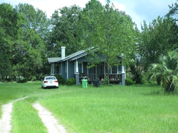
24929 CRAWFORD RD
CALLAHAN, FL 32011
Parcel Summary
| Situs Address | 24929 CRAWFORD RD |
|---|---|
| Use Code | 0100: SINGLE FAMILY |
| Tax District | 6: Drainage Dist |
| Acreage | 3.3000 |
| Section | 11 |
| Township | 1N |
| Range | 24 |
| Subdivision | CARDINAL M PBK 5-236 |
| Exemptions | HX: Homestead (196.031(1)(a)) (100%) HB: Homestead Banded (196.031(1)(ab) (100%) |
Short Legal
LOTS 1 & 4CARDINAL MEADOWS PB 5/236
Certified Values
| STANDARD | 2024 |
|---|---|
| Land Value | $82,500 |
| (+) Improved Value | $112,175 |
| (=) Market Value | $194,675 |
| (-) Agricultural Classification | $0 |
| (=) Assessed Value | $134,790 |
| (=) County Taxable Value | $84,790 |
Document/Transfer/Sales History
| Instrument / Official Record | Date | Q/U | V/I | Sale Price | Ownership |
|---|---|---|---|---|---|
| WD 2315/1913 | 2019-11-01 | Q | Improved | $115,000 | Grantor: CRAWFORD JEFFREY M & LAUREN PATRICIA (H&W) Grantee: BAILEY NICHOLAS A |
| WD 1802/1875 | 2012-07-05 | Q | Improved | $78,000 | Grantor: GEORGE SAMUEL D & ELLEN D Grantee: CRAWFORD JEFFREY M |
| QC 1538/1110 | 2007-11-30 | Q | Improved | $100 | Grantor: GEORGE SAMUEL D Grantee: GEORGE SAMUEL D & ELLEN D |
| WD 1397/1000 | 2006-03-21 | Q | Improved | $130,000 | Grantor: MIXON CLARK W Grantee: GEORGE SAMUEL D |
| QC 1323/1660 | 2005-06-08 | Q | Improved | $100 | Grantor: MIXON CLARK Grantee: MIXON CLARK W |
| WD 0934/1100 | 2000-06-01 | Q | Improved | $43,100 | Grantor: UNITED COMPANIES LENDING CORP Grantee: MIXON CLARK & CLELLA |
| CT 0925/1541 | 2000-03-27 | U | Improved | $100 | Grantor: CLERK OF COURT Grantee: UNITED COMPANIES LENDING CORP |
| WD 0716/1529 | 1994-10-25 | Q | Improved | $30,000 | Grantor: DOUBERLY JAMES C Grantee: ROWLAND WANDA |
| QC 0607/0962 | 1990-09-17 | Q | Improved | $100 | Grantor: DOUBERLY MILDRED E Grantee: DOUBERLY JAMES C |
| WD 0570/1021 | 1989-05-23 | Q | Vacant | $25,000 | Grantor: JONES ALLEN W Grantee: DOUBERLY JAMES C & M |
Buildings
Building # 1, Section # 1, 112106, RESIDENTIAL
| Heated Sq Ft | Year Built | Value |
|---|---|---|
| 1120 | 1950 | $117,301 |
Structural Elements
Extra Features
| Code | Description | Length | Width | Units | Unit Price | AYB | % Good Condition | Final Value |
|---|---|---|---|---|---|---|---|---|
| 0504 | FP-ELECTRIC | 1.00 | $2,000.00 | 1950 | 20% | $400 |
Land Lines
Personal Property
None
TRIM Notices
Property Record Cards
Disclaimer
The Nassau County Property Appraiser's Office makes every effort to produce the most accurate information possible. No warranties, expressed or implied, are provided for the data herein, its use or interpretation. The information contained herein is for ad valorem tax assessment purposes only. The Property Appraiser exercises strict auditing procedures to ensure validity of any transaction received and posted by this office but cannot be responsible for errors or omissions in the information received from external sources. Due to the elapsed time between transactions in the marketplace, and the time that those transactions are received from the public and/or other jurisdictions, some transactions will not be reflected.